Just a few weeks ago, we were training hard to conduct wildfire windshield surveys. Now with much cooler temperatures and a few days of rain, the fire threat, while still there, is diminishing. Time to switch gears as we move into October and the rains begin their regular pattern. The flood season here in beautiful, historic Centralia runs from October through February. With four “100 year flood events” in the past thirty years, we’ve learned to treat the storms that sweep in from the Pacific Ocean with care. Each year, Centralia and Lewis County experience localized flooding without exception, but the bigger flooding events that can cause real damage can also visit regularly.
Windshield surveys for wildfires and floods have their similarities but they definitely have their differences as well. The biggest difference is deployment warnings. Wildfires occur without warning and need immediate attention while we generally know a flood event is coming our way a week or two in advance. Centralia has four independent waterways that create localized flooding depending on where and how the water arrives. At its worst, flooding can and sometimes does divide our city into four separate areas where it can be difficult or even impossible to travel from one area to another. With that possibility in mind, Centralia ARES has created mobile communication vans which allow us to establish a command post wherever the need arises. We can, for example, set up a mobile communications command post in all four separate divisions of the community if necessary.
This changes the way we conduct windshield surveys as well. While the Emergency Operations Center ramps up for a community wide flood situation, ARES personnel can set up independent, local neighborhood command posts nearer to the flood problem. These communication vans can use their own ARES simplex frequency to communicate with their flood survey people or everyone can use the K7CEM repeater to keep in touch within the area.
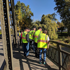
When it comes to flood windshield survey work, it is all about creating a “picture” of the community for those in charge of the Emergency Operations Center. The Incident Commander, usually a police or fire staff member, knows his community well yet, confined to the EOC, needs ARES volunteers to “paint him a picture” of what each neighborhood looks like now – or two hours from now so he can effectively deal with issues. For ARES team members this means monitoring water flow to determine if it is changing for the better or for worse. It also means conducting a street by street, neighborhood by neighborhood evaluation to determine which streets are under water, which ones must be closed and always looking for local issues such as a sink hole or vehicle driven into deep water now needing rescue.
Generally while the survey teams are working in 2-3 hour shifts, the ARES staff in the EOC begin the deployment process and area assignments. After a situation briefing, safety briefing and area/frequency assignments, survey teams are sent to their survey areas where they check in with the nearest communications van who then is responsible for the survey deployment. For the most part, it is not dangerous work but often boring work. Nevertheless, the information provided is important to the command structure in the Emergency Operations Center. There are times when the EOC remains closed if the event is predicted to be small and of short duration. In these cases ARES teams will often conduct windshield surveys just to stay ahead of the issue. Sometimes an hour or two’s warning can make the difference.
The 1986 “100 year flood” event was somewhat of a surprise mostly because none of the police and fire personnel had experienced such an event. Still, it was a madhouse scramble, often in the dark, as first responders evacuated nursing homes and families. The 1996 “100 year flood” closed Interstate 5 for four days and flooded local businesses with up to 14 feet of water. By far, the 2007 flood was the worst in recent memory. Not because it was huge or even because it closed the freeway for four days once again. This flood was an out and out surprise. Weather forecasts predicted a heavy local rain that would pass to the east. Instead the huge rain cell stalled over the local Willapa Hills (unknown to the weather service) and dumped nearly 20 inches of rain into the local Chehalis River system. By the time the wall of water, which destroyed bridges, railroads and homes in its path, became known, it was to late to do anything but react, and we were slow to do that as well.
Flooding will always be a part of our area and I’m sure we will have yet more “100 year flood” events but we may have learned some lessons over the years. Now, we watch and monitor large rain events carefully. We have learned to ramp up the Emergency Operations Center sooner and prepare better. Amateur Radio Emergency Service teams are and will be a part of that preparation into the future. Yes, October means a change in the way we train for our ARES team of volunteers but that is just fine with us.